Trekking the Swiss Section of the Via Alpina: From Liechtenstein to Lake Geneva
Arnaud Delamare · Sunday, January 25, 2026
The Swiss section of the Via Alpina stretches across the full breadth of the country, starting at the eastern border of Switzerland near Austria’s Tyrol and Liechtenstein and ending on the shores of Lake Geneva, close to the French border. This long-distance route forms part of the wider Via Alpina network, which links the Alps from the Adriatic to the Mediterranean, and represents one of the most complete alpine crossings available to hikers.
In Switzerland, the Via Alpina unfolds as a continuous journey through contrasting landscapes and cultures. Over roughly 390 km, it crosses seven cantons — St. Gallen, Glarus, Uri, Obwalden, Nidwalden, Bern, and Vaud — guiding hikers from German-speaking eastern valleys to the French-speaking west. Along the way, alpine passes, glacial valleys, pastoral plateaus, and lakeside promenades create a constantly evolving sense of place.
Vaduz and the Eastern Alps
The journey begins near Vaduz, the capital of Liechtenstein, set against the wide Rhine Valley and the limestone ridges of the Eastern Alps. This opening section introduces hikers to the alpine world gently, with open hillsides, panoramic viewpoints, and historic landmarks such as hilltop castles and centuries-old mountain farms.
Walking westward from Vaduz, the trail transitions smoothly into Swiss territory, following ancient paths once used by farmers, traders, and shepherds. Forested slopes alternate with open pastures, and the views gradually widen as elevation increases. It is a calm and scenic beginning, allowing hikers to settle into the rhythm of long-distance trekking.
Beyond its scenery, this eastern section reflects a deep-rooted alpine culture. Seasonal grazing, wooden chalets, and small mountain chapels reveal a landscape shaped by generations of mountain life. The Via Alpina here is as much a cultural journey as a physical one.
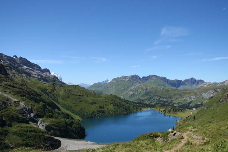
Engstlensee and Alpine Meadows
As the route continues west, it reaches the high plateau of Engstlensee, a striking alpine lake surrounded by rolling ridges and grassy slopes. The lake’s turquoise colour contrasts beautifully with the muted greens of surrounding pastures and the rocky summits above. It is a natural pause in the journey, offering wide-open views and a sense of alpine calm.
The meadows around Engstlensee are classic Swiss alpine terrain: grazing cattle, traditional huts, and sweeping horizons. Trails in this area are well-marked and varied, allowing hikers to choose between gentle contour paths or slightly higher traverses with expansive viewpoints.
This section is also ideal for acclimatization. Moderate elevation gain, open terrain, and excellent visibility make it one of the most enjoyable and approachable high-alpine stretches of the Swiss Via Alpina.
 CC BY 2.0
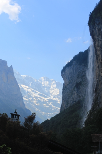
Grindelwald and Lauterbrunnen
Deeper into the Bernese Alps, the Via Alpina arrives in Grindelwald, dramatically framed by the iconic trio of Eiger, Mönch, and Jungfrau. Few places in the Alps offer such immediate proximity to world-famous summits. Glaciers, vertical rock faces, and alpine forests combine to create a powerful mountain atmosphere.
Grindelwald itself is lively yet deeply rooted in alpine tradition. Trails fan out in every direction, offering everything from panoramic balcony paths to rugged mountain crossings. The Via Alpina weaves through this landscape, giving hikers constant visual contact with some of the most legendary peaks in Europe.
From Grindelwald, the route descends into the Lauterbrunnen Valley, a dramatic trough carved by glaciers and lined with sheer cliffs. Waterfalls plunge from hanging valleys above, earning Lauterbrunnen its reputation as one of Switzerland’s most spectacular natural settings. The contrast between high alpine exposure and sheltered valley walking is striking.
 © Easy Trek
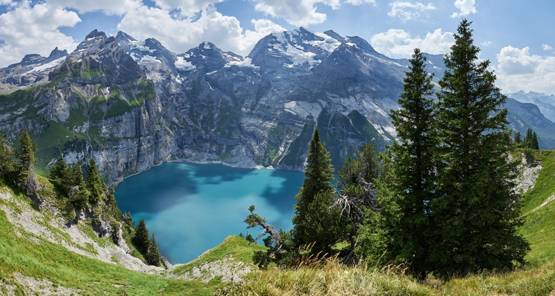
Oeschinensee and High Alpine Lakes
Continuing westward, the trail leads toward Oeschinensee, one of Switzerland’s most celebrated alpine lakes. Encircled by steep rock walls and snow-streaked summits, the lake’s deep blue waters reflect the surrounding peaks in ever-changing light.
Hiking around Oeschinensee offers multiple perspectives: quiet lakeside paths, elevated viewpoints, and routes that climb toward higher ridges. Despite its popularity, it remains easy to find tranquil corners where nature dominates the experience.
This area highlights one of the Via Alpina’s strengths — the ability to combine dramatic alpine scenery with accessible infrastructure, making high-mountain landscapes reachable without sacrificing immersion.
 CC BY-SA 3.0
Gstaad and the Bernese Oberland
Leaving the higher mountains behind, the Via Alpina enters the rolling terrain of the Bernese Oberland, gradually descending toward Gstaad. The landscape softens into wide pastures, forested hills, and scattered villages where wooden chalets define the architectural rhythm.
This stretch feels expansive and pastoral. Long traverses across meadows are accompanied by distant mountain views, while forest paths provide shade and quiet. It is a transitional zone between the high Alps and western Switzerland.
Gstaad represents a meeting point of tradition and refinement. While internationally known, it remains deeply connected to alpine farming culture, offering hikers a comfortable and atmospheric stop along the route.
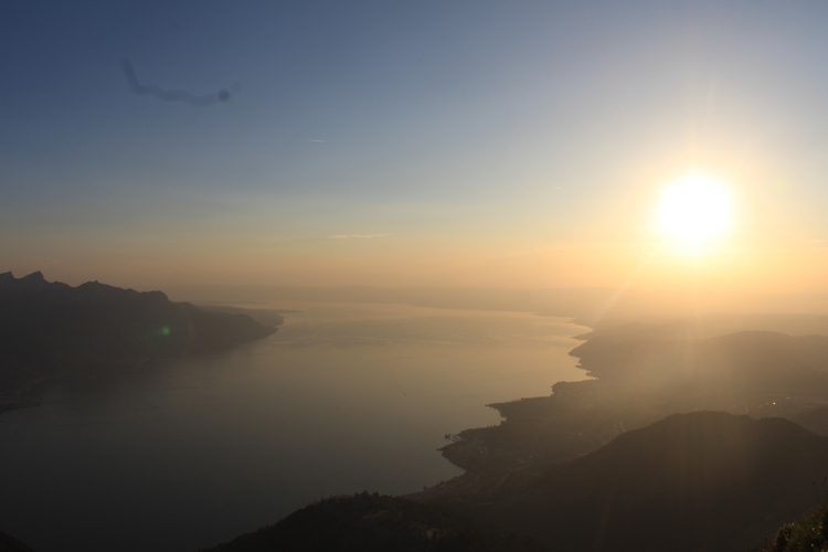
Montreux and Lake Geneva
The final stages of the Swiss Via Alpina lead to the Rochers de Naye above Montreux, where sweeping views open across Lake Geneva and the surrounding vineyards. From alpine ridges, the trail descends steadily toward a landscape shaped by sun, water, and terraces.
As elevation drops, the climate softens and Mediterranean influences become noticeable. Vineyards, palm-lined promenades, and lakeside towns replace alpine pastures, creating a powerful sense of arrival.
Reaching Montreux marks the end of the Swiss crossing — a journey that began among eastern alpine valleys and concludes beside one of Europe’s great lakes.
 © Easy Trek
Why Hike the Swiss Via Alpina?
The Swiss Via Alpina is more than a single trail — it is a complete cross-section of the country’s landscapes and cultures. Alpine passes, glacial valleys, mountain lakes, pastoral regions, and lakeside towns are all connected in one coherent journey.
Thanks to Switzerland’s dense transport network, hikers can easily adapt the route. Trains and cable cars allow for flexible access, partial itineraries, or shorter sections, depending on time and interests.
With Easy Trek, you can plan the Via Alpina exactly the way you want. Choose only your preferred start and end cities, select specific highlights, and shorten or extend the trek as needed. Whether you aim for a full east-to-west crossing or a focused regional experience, Easy Trek adapts the Via Alpina to your vision.
Arnaud Delamare
Lead developer at Easy Trek, I combine my passion for technology with my love of nature. A fan of hikes in the Jura and Valais, I never miss a chance to enjoy a sunset from the top of a trail. Between coding and breathtaking views, I turn every idea into an experience on our routes.